i.imgur.com/j7GOV1F.jpeg Not all NA, but some visualization of smaller areas. Not sure why most maps want to throw in modern states when we want to look at indigenous maps.
This is by far the largest settler colony and one of the largest real, actual genocides conducted in human history. Not fake like the ones West invents about others.
There’s very less evidence to support that. I can only recall one incident where a blanket infected with small pox was handed out to a tribe and the officer who did that was later severely reprimanded.
But anyhow, I am not trying to downplay the ill intent of European settlers, I will just quote this here “history is written by victors”. The blanket incident is all I recall about deliberate disease spreading. who really knows? How many hundreds of such incidents went unreported?
I took a course about it back in high school, they literally wrote about how they were going to spread infected blankets to wipe out the indigenous population. But you’re white so that means your genocide denying hipfires are more accurate than actually educated facts on the matter, so excuse me for thinking I knew what I was talking about.
You can start the journey of learning the truth here. There are lots of sources of info ( if you ignore Canada/ USAs own accounts in some instances because of whitewashing history) . Also the churches reporting many died of germs from early settlers is a fake after take, because in that era they had no concept of germ theory, that discovery came later.
The ones in China, Russia, North Korea and whoever is the enemy of USA. Ironically, USA has been part in most genocides ever committed, some done by themselves and none that they actually discovered via authentic journalistic investigations.
Okay let’s break this down into the three unrelated parts:
Which genocides? Sounds to me like you know that the genocides you’re referring to actually have huge amounts of evidence, so you’re intentionally avoiding saying which specifically to avoid scrutiny.
Most genocides ever committed? The country has only existed since 1776, and humans have been committing genocide for a hell of a lot longer than that.
none that they actually discovered via authentic journalistic investigations
What the hell is that meant to mean? Who is “they”? None of what? What makes a journalist’s investigation “authentic”?
Nonono, you’ve passed the point of getting off that ride.
What’s happened here is you came in spouting absolute bullshit with nothing to back it up. Then you got called out for it by this “hipster”, and realising that, you’re trying to back out by pretending you never wanted to have this conversation in the first place.
Now you’re doing the internet equivalent of putting your fingers in your ears and yelling LALALA to convince yourself you’re right, and that you’re not giving your government a free pass to commit genocide, it’s just those damn westerners trying to “make you have morals” and “form sentences that actually mean something”.
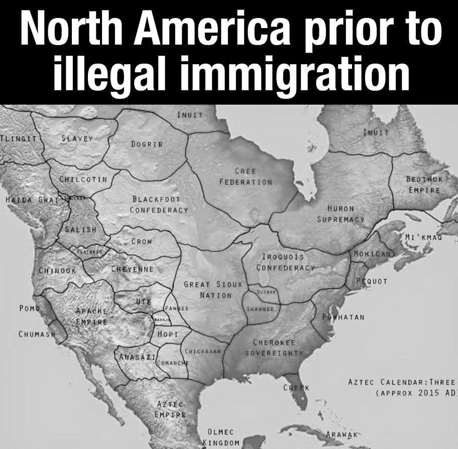
In the bottom left it shows the current year in the Aztec calendar, presumably cut off and the “current year” in the Gregorian calendar at 2015 AD. I’m 95% sure this is just some guy’s alt history map, especially considering how many wack ass names some of these places have
It’s definitely an alternate history map, and I hope it’s an accurate potential map of an uncolonized North America if it’s cultures grew to nation state sizes.
I’m European so I’m not meaning to offend, but there’s something very interesting to me try to visualise how America could have grown without colonisation, and perhaps this is through my European lense but I’d imagine borders would move and groups would swallow eachother up. The scale of countries on this map is pretty comparable to what we see in Europe and Asia, but I don’t know enough about America to know if this is respectful to the placement and potential of Native American groups (e.g I think I’ve read before the the Comanche are a successful seperation from the Shoshone that was largely due to their expansion due to horses, which would have happened very differently sans colonisation), and I’m not even sure if this map follows natural borders like mountains and rivers, largely because I’m just not that familiar with America.
this map is complete nonsense because some of these groups only exist as a result of interactions with europeans, and even some of the other ones are from completely different places before europeans came in.
The Aztec empire being the dominant force on the continent could be a very unfortunate situation for everyone living there.
They were so unpopular with every surrounding nation (because of all the murdering and kidnapping and human sacrificing) that when the Spanish showed up, the vast vast majority of the soldiers that fought against the Aztecs were from the local peoples.
The First Peoples of North America definitely didn’t have such sharp, well defined border lines. It’s not as of they had a bunch of written treaties establishing hard borders.
This is a conceptual alternate history map of modern day North America without colonisation. It’s still reasonably inaccurate of course but it’s not meant to accurately portray the borders of a pre-colonised North America.
The Wikipedia says it comes from a French misspelling of an indigenous word that could be used to describe the people. So it might be a little less offensive than that, but still not great.
In English we use Norse meaning northern people, unsurprisingly it is the word originally used to describe them by people south of them. Those people now called Germans get their name from ceaser when he invaded from Italy, named by the Greeks, who in turn derive their modern name from the Romans because they called themselves Hellanes… Spain gets it’s name probably because it was located near a rabbit on a Roman coin… They also named Britain of course and all of them would be the ones going to the new world and naming things there
If they’d endured as independent groups into the 21st century without being colonised by Europeans, as the map shows, they would almost certainly have developed defined borders.
Why? Europe had firm (occasionally changing) boarders for centuries before the sixteenth century, do you think they were simply behind on an inevitable development or that contact with the rest of the world would necessitate their development?
I think it’s interesting to try and imagine situations where firm boarders aren’t established. In such a situation it’s interesting to consider what rules could or would exist regarding immigration and outsider communities.
yeah, but i just dont really understand the map. is it just a map showing where the native population lived before colonization or is there an actual joke in there?
Is this one of those “this is uncomfortably political to me and I don’t like that like that, therefore it isn’t a wholesome chungus 100 maymay” things? grillman


Add comment